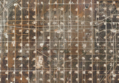
Google Street View, Google Maps, and even Google Earth are structuring our view of the contemporary world. Launched close to ten yeas ago by the web giant, these softwares are accessible to every one with an internet connection. The millions of images that they generate constitute an infinitive documentary source that is ceaselessly renewed for those who want to interpret them. Mishka Henner is part of this new generation of artists who are redefining the role of photography of the Internet era. A large part of his work consists in navigating through their vast digital territories looking for subjects of cultural and geopolitical interest. For Field, the artist spent close to two years inspecting the American continent with the help of visuals taken thousands of kilometers from Earth. The image, which spreads across a thirteen-meter length, is the result of an assembly of hundreds of very high-definition satellite photographs found freely accessible on the web. His checkered pattern seems at first to be a geometrically abstract painting, yet, looking more closely, we discover one of the biggest oilfields of the center of the United States. Located in Wickett, Texas, North Ward Estes has been, for hundreds of years, supplying the ever increasing energy needs of Americans. This area stretches over 96 square meter and comprised 935 production wells and 440 injection wells, some of which are no longer active. To extract the oil, 9,000 million liters of carbon dioxide are injected into the ground each day. The impact of these extraction practices are clearly visible. Mishka Henner gives us a frightening view of these oil drillings, which represent, according to the artist, cultural as much as industrial landscapes. This satellite picture of unlikely beauty is captivating in many ways and also turns out to be “photo evidence” of the destruction inflicted on our planet.
Nathalie Herschdorfer
Mishka Henner, Field
Through October 16, 2016
Musée des beaux-arts du Locle
Rue Marie-Anne-Calame 6
2400 Le Locle, Switzerland

