Avenue de l’Opéra
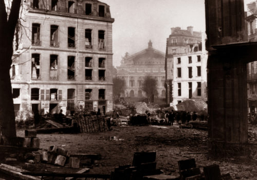
The numerous photos taken by Charles Marville are interesting for many reasons. They not only show the street’s beginnings, but also the means used to build the titanic construction projects in Paris under the Second Empire. Shovels, pics, a few horse-drawn carriages to remove rocks and gravel, and men – nearly 70,000 of them every year – that knocked down buildings from top to bottom with axes. Pictures taken from the rue d’Antin.
Situated between the first and the second arrondissements, this major avenue begins place du Théâtre-Français and ends place de l’Opéra. It was opened in three stages. The first stage, in 1864, between the rue Louis-le-Grand and the boulevard des Capucines, the second in 1867, between the place du Théâtre-Français and the rues de l’Echelle and Molière, and finally, in 1876, the section stretching from the rues de L’Echelle and Molière and the rue Louis-le-Grand. It was first named avenue Napoléon before adopting, in 1873, its current name, an homage to the Théâtre National de l’Opéra at the avenue’s end.
On the historical picture, we have a view of the future location for the avenue de l’Opéra (1877).
The buildings in the forefront would soon be demolished and replaced by buildings as seen in the current picture, with their lovely Hausmanniennes façades.
Opéra de Paris
Located between the place de l’Opéra and the place Diaghilev, the first stone was posed in 1872. Inaugurated on January 5, 1875, today it is the symbol of the rich architectural heritage of the Second Empire.
During a construction site visit alongside the Emperor and the baron Haussmann, the Empress Eugénie, skeptical, asked the architect:
– But Monsieur Garnier, what style is it?
– Napolean the 3rd, her Majesty, he answered.
“The new Opera just opened and it has the appearance of great prosperity. It is already a historical monument, visually and aesthetically it boasts everything the Empire claimed to be, and it became a symbol – a very positive symbol – of the Empire’s gift to France. Although opinions may differ about the building’s beauty, in my opinion, it is not pretty, no one can deny how it clearly reflects the time period and tells the story of the society that built it. If that, as some believe, is the definition of a great building, then the Opera is an incomparable success”, Henry James, “Parisian Sketches”, 1875.
Rue Réaumur
Rue Réaumur begins at the rue du Temple and ends at the rue Notre-Dame-des-Victoires. This street began as the prolongation of two streets in 1765, connecting the late Saint Martin Market, from the rue Saint-Martin to the rue Volta. These two streets were united in 1851 and named Réaumur after the great 18th century physicist. It was extended to the East in 1858, from the rue Volta to the rue du Temple. Its Western section, located between the rue Saint-Denis and the rue Notre-Dame-des-Victoires, traced in 1864, wasn’t finished until February 1897.
Shots taken from the rue Réaumur towards the rue Saint-Martin, from the rue Réaumur, at the intersection with the rues Turbigo and Montgolfier. On Marville’s picture, behind the soon to be destroyed buildings, the bell tower.
Boulevard Henri IV
It begins at the quai de Béthune and ends at the place de la Bastille and the boulevard Bourdon. The new boulevard Henri IV was traced in 1866 to connect the Seine to the Bastille. To build this boulevard, not only was the hôtel des Lesdiguières at the corner of the rue de la Cerisaie destroyed in 1878, but also the Parisian monastery built under François Ier, boasting one of the greatest collections of artwork. The boulevard is also home to the bibliothèque de l’Arsenal, résidence de Sully, where Henri IV went the day of his assassination by Ravaillac on the rue de la Ferronnerie. On November 10, 1877, the boulevard was officially named after the King and Sully was assigned to the bridge adjacent to the bibliothèque de l’Arsenal extending from the colonne de Juillet, connecting the new boulevards Henri IV and Saint-Germain.
Taken from the place de la Bastille near the caserne des Célestins (on the right). In the background, the colonne de juillet, in the center, the place de la République, named to commemorate the three days of insurrection, 27, 28, and 29 July 1830, otherwise known as the “Trois Glorieuses”.
Notre-Dame, former Hôtel-Dieu and Petit-Pont
Founded in 651 by Saint Landry, Hôtel Dieu is the capital city’s oldest hospital. Symbol of charity and hospitality, it was the only Parisian hospital until the Renaissance. In 1772, a fire destroyed a large part of the hospital. Several new buildings were constructed and the hospital was redesigned. The Hôtel Dieu was outpaced by fellow Parisian hospitals including Saint Louis and La Pitié, each with specialties in clinical cases. During the Second Empire, the buildings were no longer adapted. The Baron Haussmann had the Hôtel Dieu moved and rebuilt near the Notre Dame Cathedral, between the new rue d’Arcole and the Parvis. In the background, on the right, the old home for lost children (destroyed during the reconstruction of the Île de la Cité under the Second Empire.
The quai Saint-Michel (on the right). Moving the Hôtel-Dieu opened a view of the cathédrale from the banks of the Seine. On the left, the Préfecture de Police (Caserne de la Cité, 1860) built on the quai du Marché-Neuf. In the background the trees from the square Jean-Paul II. In front of the parvis, le Petit-Pont, the shortest in Paris, existant for 20 centuries. Originally built in wood, rebuilt in stone in 1718, and rebuilt in 1853.
La Bièvre and its leather factories
La Bièvre, that starts in Guyancourt in the Yvelines, once connected with the Seine in Paris (near the gare d’Austerlitz) after traveling through the Yvelines, Essone, Hauts-de-Seine, and Val-de-Marne departments, and the 5th and 18th arrondissements. In 1912, the entire urban stretch was covered, saving residents from its noxious odors, a result of the region’s tanneries. Today, it ends in one of the city’s major gutters. Its name comes from the latin biber, bièvre, and is the former name for a beavor, or from beber which means brown, likes its waters. The arms of the 18th arrondissement are proudly held by two castors. The writer Huysmans described the river as follows: “Like many country girls, the Bièvre, upon its arrival in Paris, fell into the industrial flow of bandits; their herbal outfits and tree-lined jewels were stolen, so she had to go to work, exhausting herself on the horrible tasks asked of her… Along her banks, she became a leather worker, spending her days and nights washing skins, soaking the raw leather, suffering from the effects of the alun, and the lime’s caustic bites. Only at night, behind the Gobelins, in a horribly stinking smoke, can we see her, standing in the mud, to the light of the moon, stupefied with fatigue.” In “La Bièvre.”
Rue Censier (Ve). On the right, the beginning of the rue Santeuil. The rue Censier follows the course of the Bièvre.
Patrice de Moncan
PARIS, Avant/Après – 19e siècle et 21e siècle, Patrice de Moncan, Editions du Mécène, 45,00 €